Mapping Iroquoia
![]()
Click on anchor points to view corresponding panel and title. You can move the map around by clicking and dragging. View a larger version of the map by clicking on the [ ] brackets on the top right of the map.
![]()
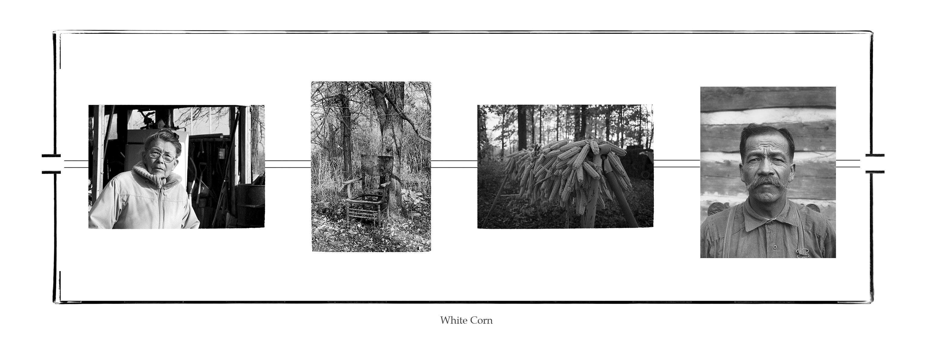
1. Wampum Belt #1 White Corn (2014/2018) pigment print on archival paper
KEY TO IMAGES (left to right)
Jeff Thomas, Emily General (1985) Smooth Town, Six Nations Reserve. GPS: 43.01945, -80.08303
Emily General is my great-aunt and sister to my step-grandfather Bert General. Emily was instrumental in helping me define my sense of place as an urban Iroquoian. When I entered university in 1975 she gave me her copy of the handwritten story of the Peacemaker and his journey to bring peace to the warring Iroquois tribes in present-day New York State. Emily told me I could not use a photocopy machine, I had to make my own hand-written copy of the 1900 document. I did and it has been instrumental for my development as a visual artist and curator.
Jeff Thomas, Old Chair outside Emily General’s kitchen door (1985) Six Nations Reserve, Ontario. GPS: 43.01945, -80.08303
I photographed the old chair sitting outside of Emily’s kitchen door because it reminded me of the times I sat at the kitchen, listening to my elders tell stories about the old days, gossip, the price of farm animals, etc. I thought that might be my last visit to the farm and I wanted an image to remember my time with Emily.
Jeff Thomas, Drying white corn braided by Bert General (1990) Six Nations Reserve, Ontario. GPS: 43.018067 -80.08955
Francis Knowles, Chief Jacob General (1912) Six Nations of the Grand River, Canadian Museum of History. GPS: 43.018067 -80.08955
Bert and Emily had provided me with enough information to begin my journey of discovery. The Hiawatha wampum belt commemorated the Peacemaker’s journey through ancient Iroquoia and the story Emily gave me became the prototype for this journey and would lead to my self-identification as an urban Iroquois.
![]()
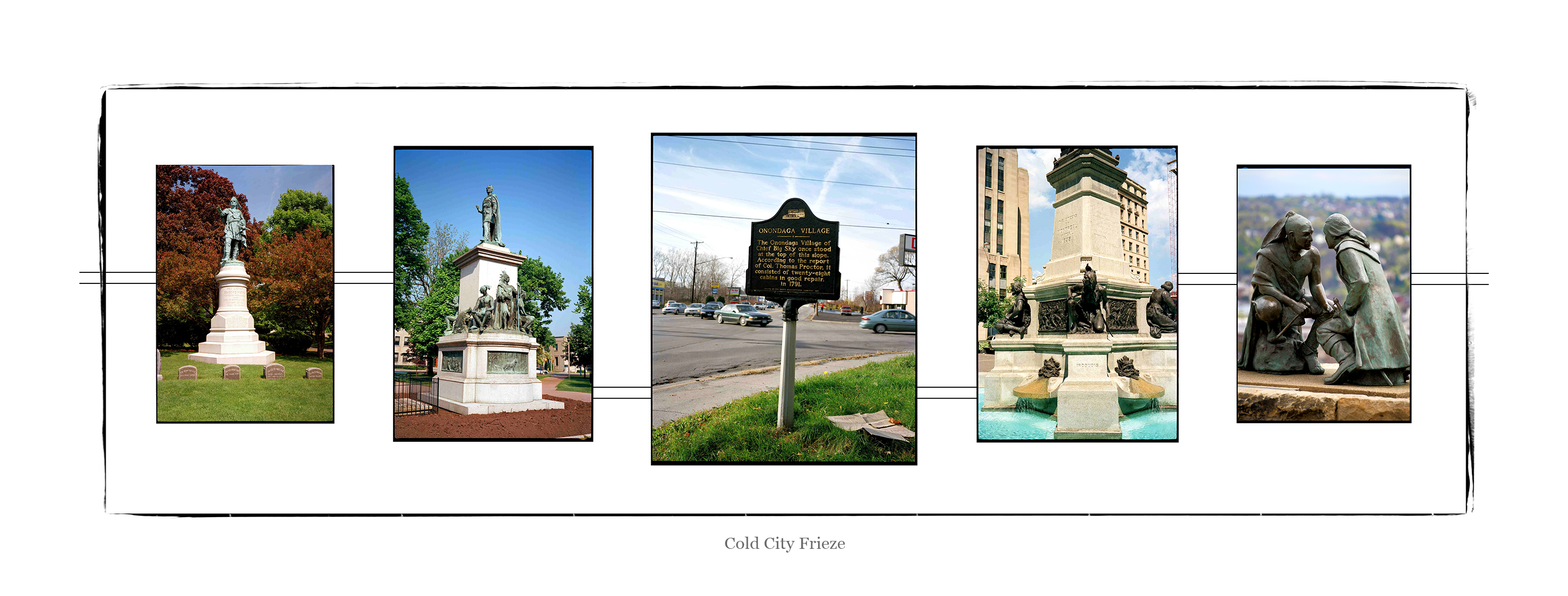
2. Wampum Belt #2, Cold City Frieze (1997/2016) pigment print on archival paper
KEY TO IMAGES (left to right):
Jeff Thomas, Chief Red Jacket monument (1997) Forest Lawn Cemetery, Buffalo, New York. GPS: 42.92315,-78.8663
Jeff Thomas, Joseph Brant monument (1997) Brantford, Ontario. GPS: 43.14077, -80.26331
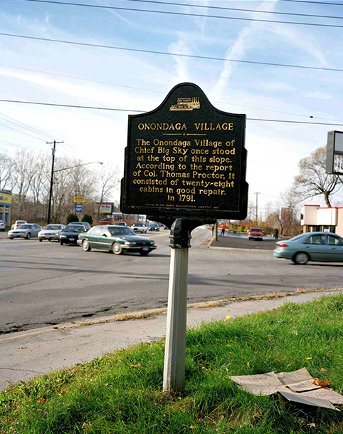
Jeff Thomas, Onondaga Chief Big Sky plaque (1997) Buffalo, New York. GPS: 42.829767,-78.773417
Jeff Thomas, IROQUOIS (1998) Place d’ Armes, Montreal, Quebec. GPS: 45.50485,-73.557667
Jeff Thomas, Point of View (2015) Pittsburgh, Pennsylvania. GPS: 40.4391,-80.021367
![]()
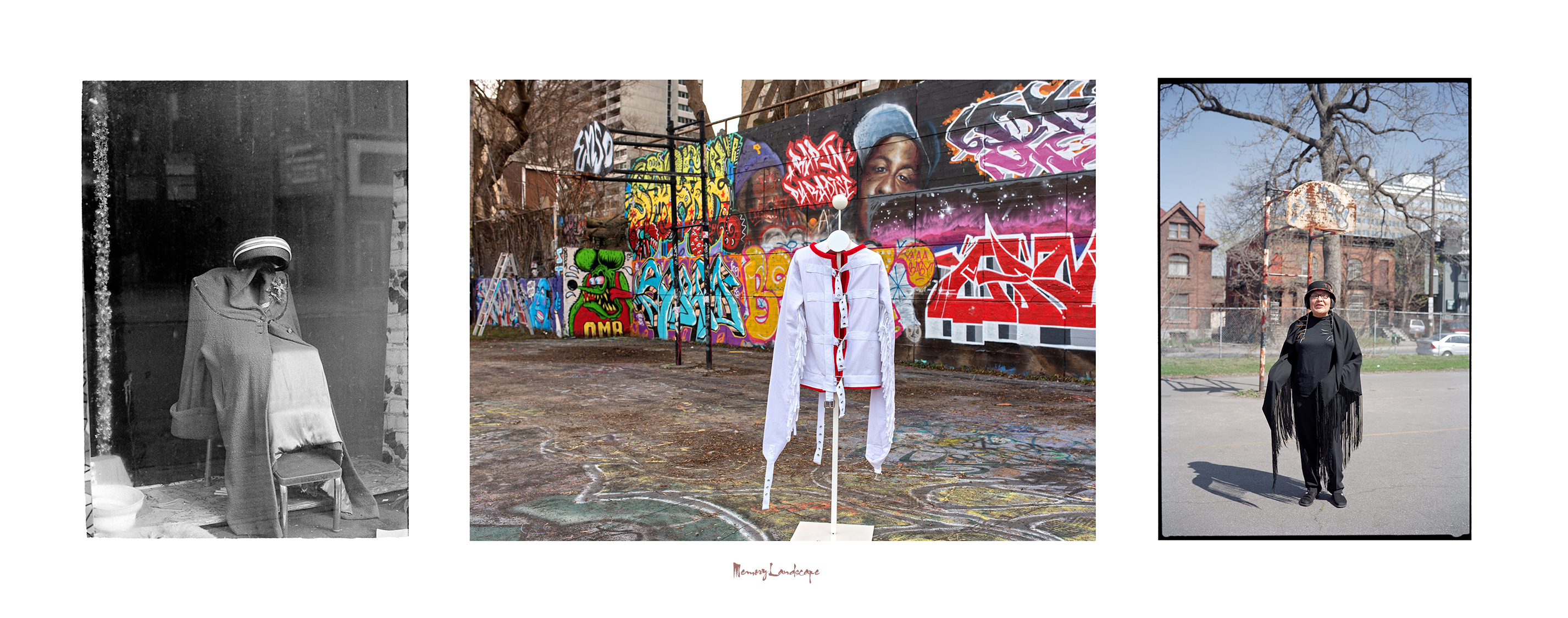
3. Memory Landscape (2015) pigment print on archival paper
While scouting the streets of Buffalo, New York, Toronto, Ontario, Winnipeg, Manitoba, and Ottawa, Ontario, for Indians, I have also questioned the stories the landscape has to tell me. Is there anything Indigenous about this landscape? I am speaking about the Europeanization of Turtle Island and how it inspired my quest to define my place as an urban-based Iroquois.
KEY TO IMAGES (left to right):
Jeff Thomas, Storefront Window Display (1982) Allen Street, Buffalo, New York. GPS: 42.89918,-78.87084
Jeff Thomas, “This Is The Problem,” jacket by artist Tanya Harnett (2015) Tech Wall site, Slater & Bronson, Ottawa, Ontario. GPS: 45.41572, -75.70726
Jeff Thomas, Madeline Dion Stout, Cree (2002) Tech Wall site, Slater & Bronson, Ottawa, Ontario. GPS: 45.4153413 -75.7068984
![]()

4. Tailgate Family Portrait (2017) pigment print on archival paper
KEY TO IMAGES (left to right):
Frank M. Pebbles (American, 1839-1928), Dr. Oronhyatekha (1841-1907), Royal Ontario Museum, ROM2008_10224_1, GPS: 43.6677 -79.39477
ORONHYATEKHA 1841-1907 (Oh-ron-ya-TEK-a) The renowned Mohawk chief, orator and physician is buried in this churchyard. Born on the Grand River Reservation, he attended the Universities of Toronto and Oxford. At the age of twenty he was selected by the Six Nations to present official greetings to the visiting Prince of Wales. In 1871 he was a member of Canada’s first Wimbledon rifle team and in 1874 became President of the Grand Council of Canadian Chiefs. Oronhyatekha was largely responsible for the successful organization of the Independent Order of Foresters.
Jeff Thomas, Clara Thomas (my grandmother), Martin Thomas (my father), Bear (my son) and nephews, Cleve, Levi and Spencer Thomas (1990) Six Nations Reserve, Ontario. GPS: 43.018067 -80.08955
![]()
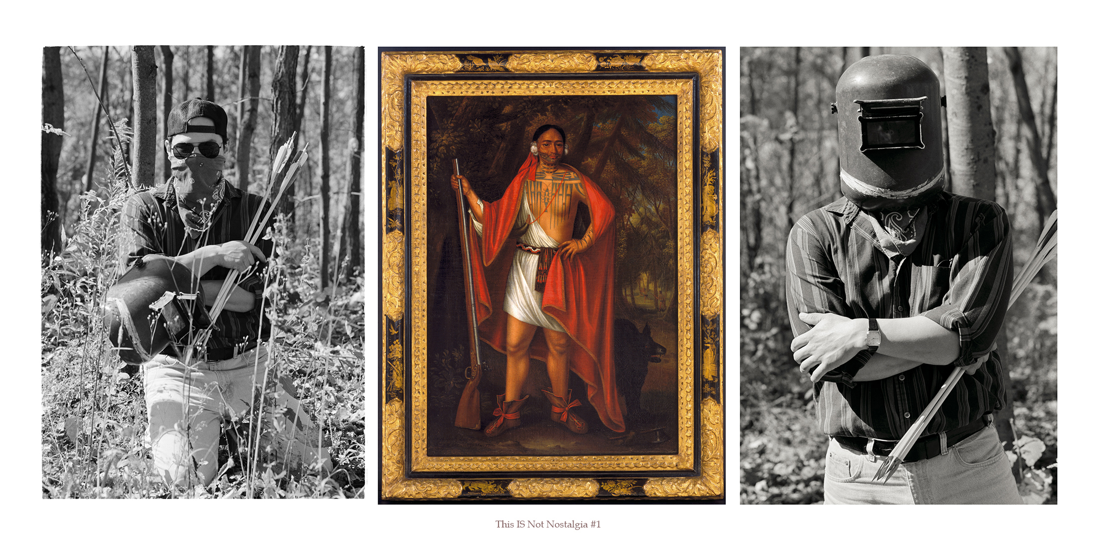
5. This Is Not Nostalgia #1 (2006/2016) pigment print on archival paper
A wistful or excessively sentimental yearning for return to or of some past period or irrecoverable condition.
KEY TO IMAGES (left to right):
(Left and Right) Jeff Thomas, Steve Thomas (Onondaga) (1990) Smooth Town, Six Nations Reserve, Ontario, photographed outside his home, GPS: 43.03222, -80.07591
(Centre) John (Jan) Verelst, Brant 1710, courtesy Library Archives Canada/C-092419. GPS: 45.42005 -75.70789
Also known as Jan or Johannes (1648-1734), was a Dutch Golden Age painter, working in England, in the time of Queen Anne’s War.
![]()
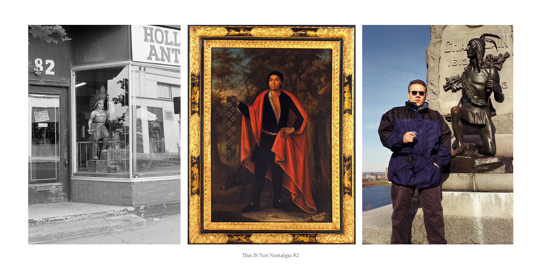
6. This Is Not Nostalgia #2 (2006/2018) pigment print on archival paper
A wistful or excessively sentimental yearning for return to or of some past period or irrecoverable condition
KEY TO IMAGES (left to right):
Jeff Thomas, Holland Antiques (1982) Buffalo, New York. GPS: 42.89916, -78.8773
John (Jan) Verelst, Hendrick (Theyanoguin) (1710) courtesy Library Archives Canada/C-092415. GPS: 45.42005, -75.70789
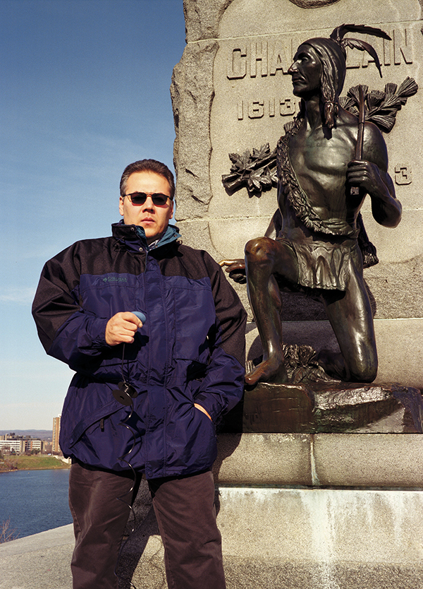
Jeff Thomas, (Onondaga), self-portrait 1998, Samuel de Champlain monument, Ottawa, Ontario. GPS: 45.4294,-75.70145
![]()

7. This Is Not Nostalgia #3 (2006/2018) pigment print on archival paper
A wistful or excessively sentimental yearning for return to or of some past period or irrecoverable condition
KEY TO IMAGES (left to right):
Jeff Thomas, Joseph Tehwehron David (1957–2004), (1997) Mohawk, artist, and veteran of the 1990 Oka Crisis, Kanehsatà:ke, Quebec. GPS: 45.47321, -74.125
John (Jan) Verelst, John of Canajoharie (1710) Courtesy Library Archives Canada/C-092417, LAC, Ottawa, Ontario. GPS: 45.42005, -75.70789
Jeff Thomas, Bear Thomas, Cayuga (1996) Samuel de Champlain Monument, Ottawa, Ontario. GPS: 45.4294, -75.70145
I discovered background information about the three men on my son Bear’s tee-shirt. The original image is a studio portrait (possibly in Omaha, Nebraska) by William Henry Jackson; the men are identified as Pawnee Scouts. The portrait’s date is circa 1868-1871.
(First from right) ‘Man who left his enemy lying in the water’, Raruur tkahaareesaaru ‘His Chiefly Night’, or ‘Night Chief’ Ticteesaaraahki’ ‘One who strikes the chiefs first’ Tirawa t Reesa ru’ ‘Sky Chief’ Standing, Baptiste Bayhylle, Resa ru’ Siriite‚riku “The Heavens See Him as a Chief”, Pawnee/French interpreter. The seated men are identified as brothers. Smithsonian Institution, National Anthropological Archives, 1297.
![]()
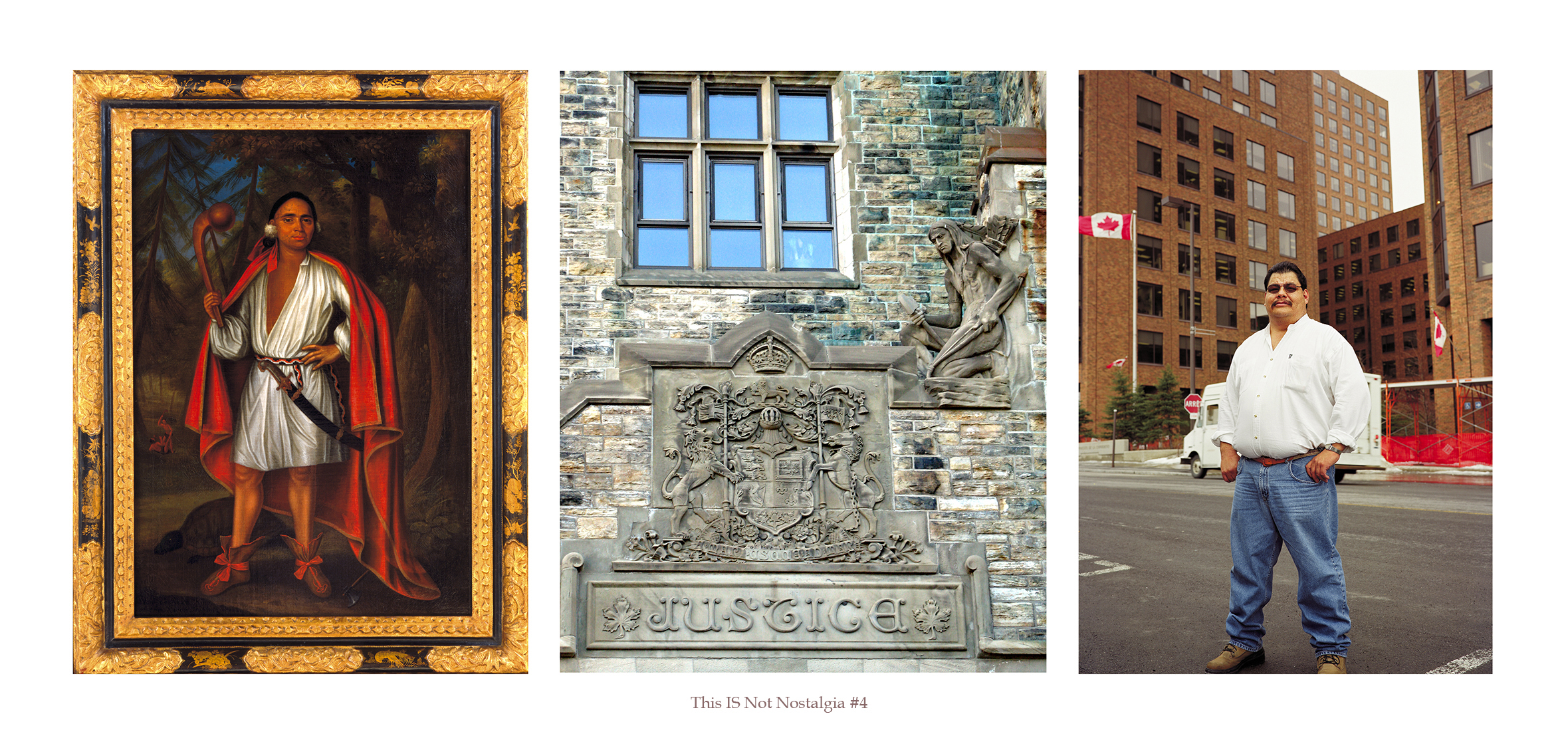
8. This Is Not Nostalgia #4 (2006/2018) pigment print on archival paper
A wistful or excessively sentimental yearning for return to or of some past period or irrecoverable condition
KEY TO IMAGES (left to right):
John (Jan) Verelst, Nicholas the Mahican (1710) courtesy Library Archives Canada/C-092421. GPS: 45.42005, -75.70789
Jeff Thomas, Justice (2006) Department of Justice building, Ottawa, Ontario. GPS: 45.42142, -75.70399
Jeff Thomas, Arnold Boyer (Mohawk), (1998) Department of Aboriginal and Northern Affairs, Gatineau, Quebec. GPS: 45.42605, -75.72173
![]()
View the other Portfolios from this series:
STRONG HEARTS: MY JOURNEY WITH BIRDMAN
REBINDING THE NORTH AMERICAN INDIAN
MAPPING IROQUOIA
THE EUROPEANIZATION OF TURTLE ISLAND
![]()


![]()