The Europeanization of Turtle Island
![]()
Click on anchor points to view corresponding panel and title. You can move the map around by clicking and dragging. View a larger version of the map by clicking on the [ ] brackets on the top right of the map.
![]()
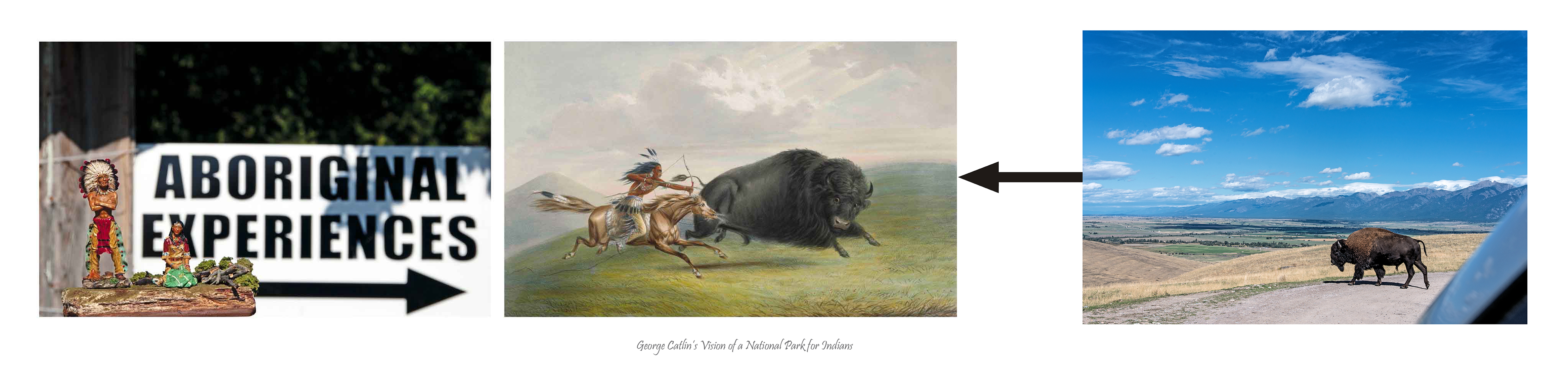
1. Aboriginal Experiences (George Catlin’s Dream Park), (2010/2018) pigment print on archival paper
Preserved in their pristine beauty and wildness, in a magnificent park, where the world could see for ages to come, the native Indian in his classic attire, galloping his wild horse.
KEY TO IMAGES (left to right)
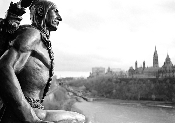
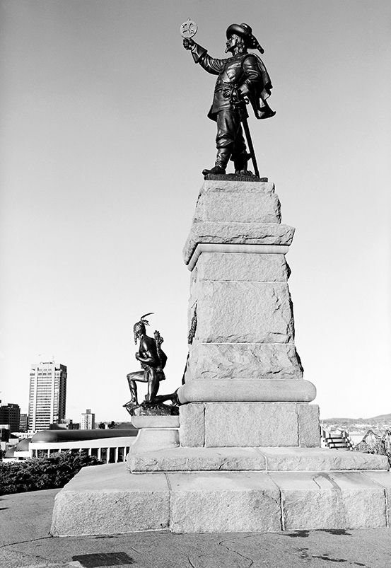
Jeff Thomas, Indian Couple, Victoria Island (Algonquin Anishinabeg unceded territory), (2009) Ottawa, Ontario. GPS: 45.4218, -75.71107
George Catlin, Buffalo Hunt, courtesy Library Archives Canada/1989-292-5. GPS: 45.42005, -75.70789,
Jeff Thomas, National Bison Range, northern western Montana (2015) GPS: 47.35616, -114.18123, elevation: 2721 ft.
George Catlin envisioned a special park where Indian people in the West could live their ancient way of life, unmolested and protected against the advancement of white settlement in their homeland. The Indian couple in my panel is on their way to see the stockade Indian village at the tip of Victoria Island. Back dropped by the Canadian Parliament buildings, the island is part of a contested site that Algonquin Anishinaabe people say was never sold to white people. Aboriginal Experiences is an Indigenous run business and in part, I see it as a modern representation of Catlin’s vision. It attracts tourists from around the world and who eat Indigenous food and watch Indigenous dances.
As a map-based project, I purchased Catlin’s buffalo hunt from Library and Archives Canada collection, which is across the river from Aboriginal Experiences. And about a kilometer away, in Gatineau, Québec, is the national office of the Department of Indigenous Affairs.
![]()
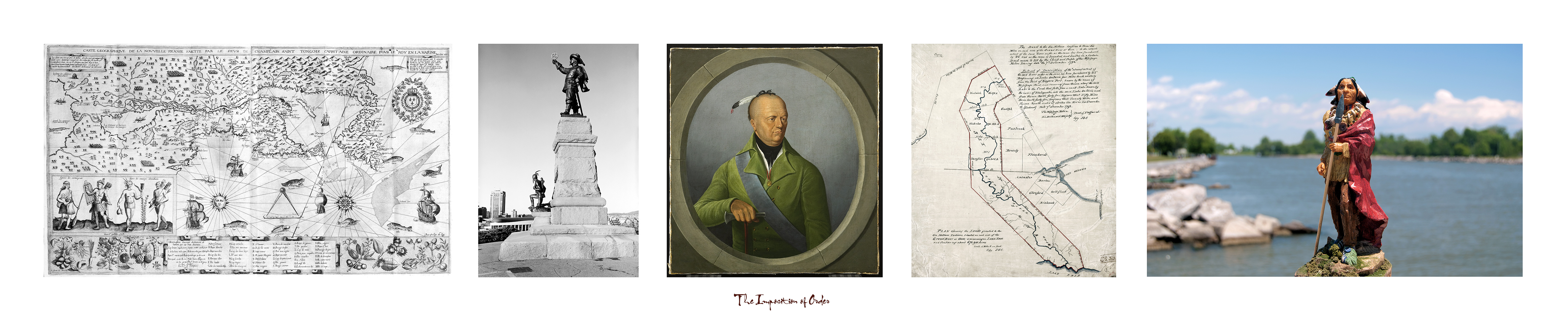
2. Imposition of Order (2017/2018) pigment print on archival paper
KEY TO IMAGES (left to right):
Samuel de Champlain, Geographical map of the New Franse made by the Sieur de Champlain Saint Tongois Ordinary Capitaine for the King in the Navy. Faict len 1612. Institution: courtesy Library and Archives Canada, e010764733
This map, engraved in 1612, was published in Samuel de Champlain’s Les voyages de 1613 (attached at the end of the volume, see Amicus 4700723). It represents the territory explored by Champlain up to 1611 as well as information he had gleaned from Amerindians and other European explorers and cartographers.
Jeff Thomas, Samuel de Champlain Monument (1992) Ottawa, Ontario. GPS: 45.4294,-75.70145
William Berczy the Elder. Portrait of Joseph Brant (c. 1808) Oil on canvas, 38.5 x 35.5 cm. Institution: The Thomson Collection at the Art Gallery of Ontario, Toronto, Ontario. GPS: 43.6536, -79.39251
Plan shewing the Lands granted to The Six Nations Indians situated on each side of the Grand River or Ouse; commencing on Lake Erie and containing about 674,910 acres. Copy J.G. C. [with an extract from the Deed of Feoffment], 7th December 1792. Institution: Courtesy of Library and Archives Canada/ H3/410/Grand/1792
Jeff Thomas, Chief Red Robe (2007) the end of the Grand River, Port Maitland, Ontario. GPS: 42.85713,-79.57903
![]()
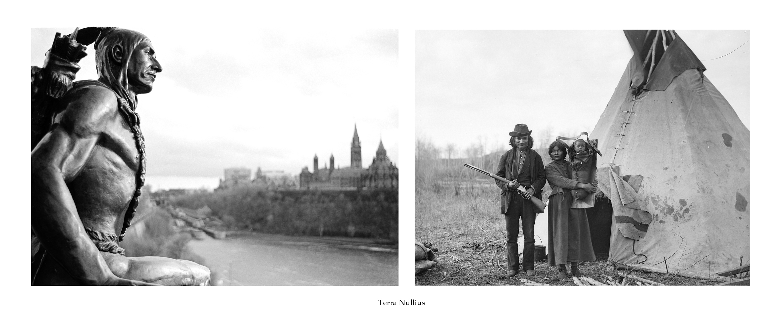
3. Terra Nullius (nobody’s land), (2018) pigment print on archival paper
KEY TO IMAGES (left to right):
Jeff Thomas, Indian Scout (1992) Samuel de Champlain Monument, Ottawa, Ontario. GPS: 45.42947, -75.70147
Joseph Burr Tyrrell, James Quesace Family (Salteaux), October 16, 1887, North West Manitoba, courtesy Library Archives Canada/ PA/-050799
![]()
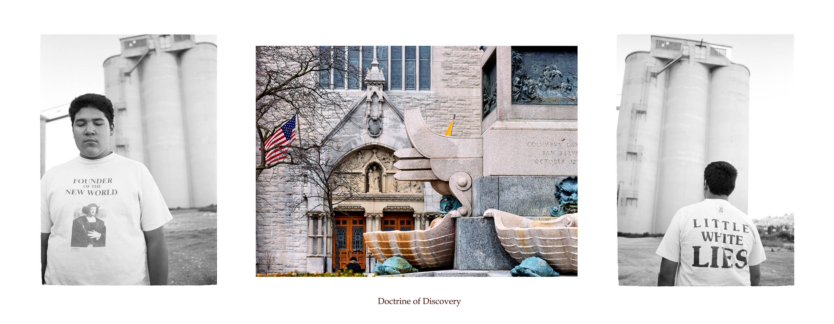
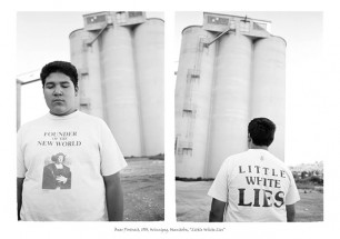
4. Doctrine of Discovery (2017/2018) pigment print on archival paper
KEY TO IMAGES (left to right):
The Doctrine of Discovery was promulgated by European monarchies in order to legitimize the colonization of lands outside of Europe. Between the mid-fifteenth century and the mid-twentieth century, this idea allowed European entities to seize lands inhabited by Indigenous peoples under the guise of discovery. In 1494, the Treaty of Tordesillas declared that only non-Christian lands could be colonized under the Discovery Doctrine.
Jeff Thomas, Little White Lies (1990) Winnipeg, Manitoba. GPS: 49.90391, -97.12856
Jeff Thomas, Christopher Columbus Monument (2015) Syracuse, New York. GPS: 43.04683, -76.14911
Jeff Thomas, Little White Lies (1990) Winnipeg, Manitoba. GPS: 49.90391, -97.12856
![]()

5. The First Spike (2018) pigment print on archival paper
KEY TO IMAGES (left to right):
Norman Denley, Canadian Pacific Railway bridge, Mountain Creek, British Columbia (ca. 1880-1890) Institution: courtesy Library Archives Canada/PA-066576
Milwaukee Railroad “Hiawatha” Advertisement Poster
Jeff Thomas, Father and Daughter (2006) Memory Junction Museum, Brighton, Ontario, GPS: 44.036183,-77.7429
![]()
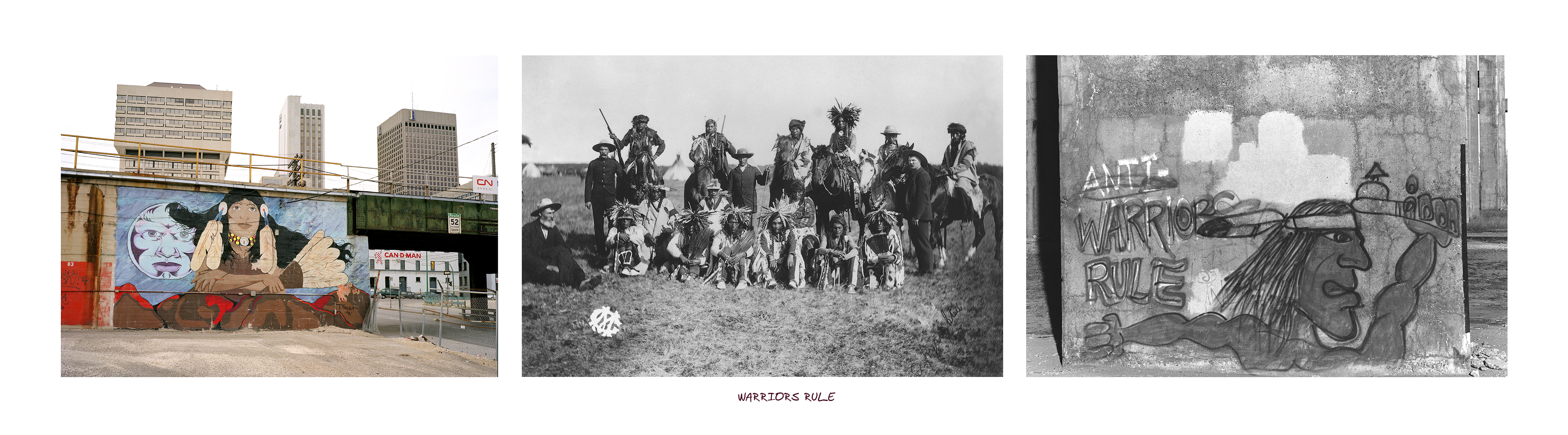
6. Warriors Rule (2009/2018) pigment print on archival paper
KEY TO IMAGES (left to right):
Jeff Thomas, Street Mural by Indigenous students (2005) located on Canadian National railroad bridge, 112-134 Pioneer Avenue, Winnipeg, Manitoba. GPS: 49.89356, -97.13477
Geraldine Moodie, Sun Dance gathering, Cree men (June 1895) Battleford Saskatchewan area. Geraldine Moodie/ Library and Archives Canada/ PA-028833. GPS: 45.42005, -75.70789
Jeff Thomas, Graffito, Mercier Bridge Pier (1994) Kahnawake Reserve, Quebec. GPS: 45.40838, -73.65948
![]()

7. Where are the Mississauga? (2017) pigment print on archival paper, 25” x 90”
TRAVELOGUE: March 18, 2005, 12:06 p.m., Mississauga exit from the QEW
I am driving around scouting for signs of Indians when I notice the Mississauga Road exit off the QEW and wonder if there are any historical markers commemorating the Mississauga people who lived here until the 1820s. I take the exit and immediately notice a historical marker by the entrance to the Mississauga Golf and Country Club. I pull over to read it and to my surprise, the plaque commemorates the Mississauga people who had built a settlement there.
I photograph the sign and continue toward the lakeshore to see what else I can find. I turn on to Mohawk Street, which becomes Hiawatha Parkway, and drive past streets with names that sound Iroquois—Minnewawa, Wenonah, Wanita, and Onaway. As I approach the lakeshore, there is a small park named Hiawatha. Was this park named after our cultural hero, Hiawatha, who spread the Peacemaker’s message of unity that established the Iroquois Confederacy?
It turned out that the answer was “no”; the park name refers to Longfellow’s poem “The Song of Hiawatha” and the streets around the park are named after fictional characters in that poem. A couple of years later, I make a return trip with my son Bear and show him the historical marker. We drive into the golf club, although a large sign states that access was limited to club members, and see a wooden pole with two carved Indian heads. It is very strange looking; probably a non-Indigenous wood carver’s idea of two Mississauga Indians.
A few years later I returned to the area and noticed that the historical plaque by the golf course was gone. So where is the evidence of the Mississauga people who lived in this area? Where are the markers to people like Maungwudaus, who lived in the area and was one of the earliest Indigenous people to be photographed.
I photograph my Indian figurine, Chief Red Robe, near an industrial site on the border of Mississauga and Oakville. I imagine what this place must have looked like 200 years ago with Indigenous people walking along the lakeshore. This image becomes my version of a historical marker and is intended to reinsert an Indigenous presence in the area.
KEY TO IMAGES (left to right):
Jeff Thomas, Queen Elizabeth Highway, Tagged Mississauga Exit Sign (2004) Mississauga, Ontario. GPS: 43.55004,-79.61727
Jeff Thomas, Credit Indian Village Historical Plaque (2004) Mississauga Golf and Country Club, 1600 Mississauga Road, Mississauga Ontario. GPS: 43.54973, -79.61997
CREDIT INDIAN VILLAGE 1826
In 1826 the government assisted a band of Mississauga, who had recently been converted to Christianity, to settle in this vicinity, and within five years laid out a village plot and constructed log cottages and a sawmill. Methodist missionaries, notably Peter Jones and Egerton Ryerson, ministered to the converts who in 1829 built a combined schoolhouse and chapel. By 1837 about 50 houses had been erected for the Indians. Three years later they had approximately 500 acres under cultivation. Pressure from local white settlement and a decline in the Indian population led to the closing of the mission and the return of the major portion of the Mississauga to the Grand River Reserve in 1847.
Unknown, Maun-gua-daus (or Maun-gwa-daus) alias George Henry (born ca. 1807), original chief of the Ojibwa Nation of Credit (Upper Canada) and interpreter employed by Indian Affairs ca. 1846; performed in George Catlin’s Indian Gallery tour in Europe. Institution: courtesy of Library and Archives Canada/ PA-125840. GPS: 45.42005, -75.70789
Jeff Thomas, Chief Red Robe (2004) outside the Petro-Canada Lubricants Centre, Southdown Road, Mississauga, Ontario. GPS: 43.49813,-79.61289
During visits to my elder’s home, I often heard them talk about the Mississauga who lived just down the road on the adjacent New Credit reserve. And when I started travelling to Toronto as an adult, and passed by the Mississauga exit sign on the Queen Elizabeth Highway (QEW), I wondered if they were the same Mississauga. One day I decided to exit and see what I could find.
![]()
![]()
8. He-Clears-A-Path (2013/2016) pigment print on archival paper
KEY TO IMAGES (left to right):
Jeff Thomas, Antone Family, Bus Shelter Poster (1990) Main Street, Winnipeg, Manitoba. GPS: 49.89724, -97.1391
Jeff Thomas, Indian Head (1990) Portage Avenue and Notre Dame Ave, Winnipeg, Manitoba. GPS: 49.89521,-97.13975
Peter Rindisbacher, A family from the tribe of the wild Saulteaux Indians on the Red River (ca. 1821) Courtesy: Peter Rindisbacher/ Library and Archives Canada, Acc. No. 1988-250. Approximate GPS: 49.88528,-97.12907
![]()
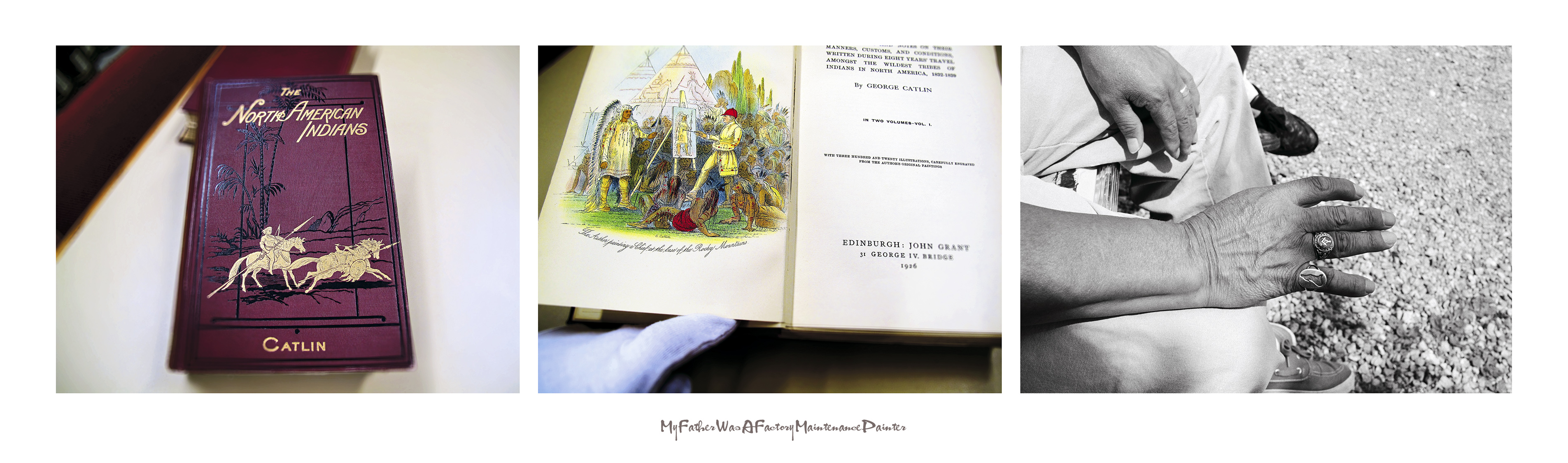
9. My Father Was A Factory Maintenance Painter (2012) pigment print on archival paper
KEY TO IMAGES (left to right):
Jeff Thomas, George Catlin’s The North American Indians, 1926, Royal Ontario Museum, Ontario, GPS: 43.6677, -79.39477
Jeff Thomas, frontispiece, George Catlin’s The North American Indians (1926) “The Author painting a Chief [Mah-to-toh-pa] the base of the Rocky Mountains,” (2006) Royal Ontario Museum, Ontario. GPS: 43.6677, -79.39477
Jeff Thomas, My Father’s Hand (1989) Six Nations Reserve, Smooth Town, GPS: 43.018067 -80.08955
![]()
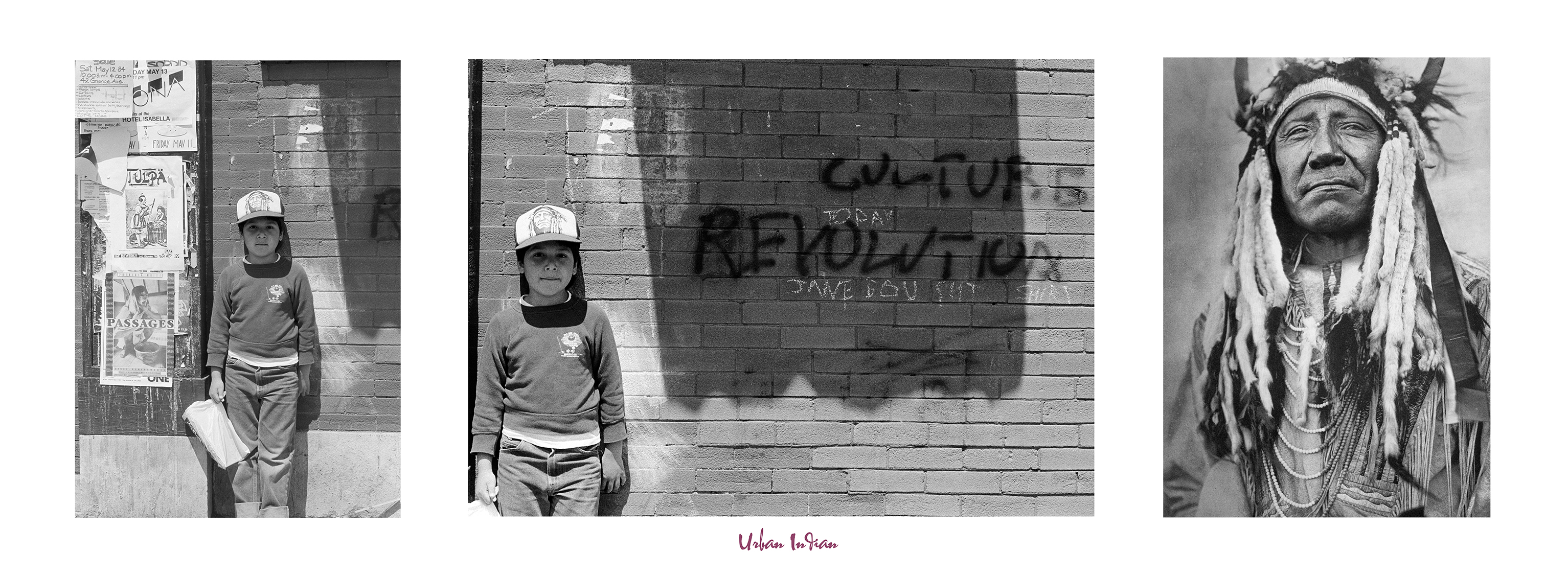
10. Urban Indian (Culture Revolution), (2017) pigment print on archival paper
Jeff Thomas, Bear Thomas (1984) Queen Street West, Toronto, Ontario. GPS: 43.6493,-79.393967
Jeff Thomas, Bear Thomas (1984) Queen Street West, Toronto, Ontario. GPS: 43.6493,-79.393967
Edward S. Curtis, Two Moons (Cheyenne), (c. 1910) Institution: courtesy of Library and Archives Canada/C-019769. Two Moons was one of the Cheyenne chiefs at the battle of Little Bighorn in 1876, when Custer’s command was annihilated by a force of Sioux and Cheyenne. “The North American Indian” – portfolio 6, plate no. 213.
![]()
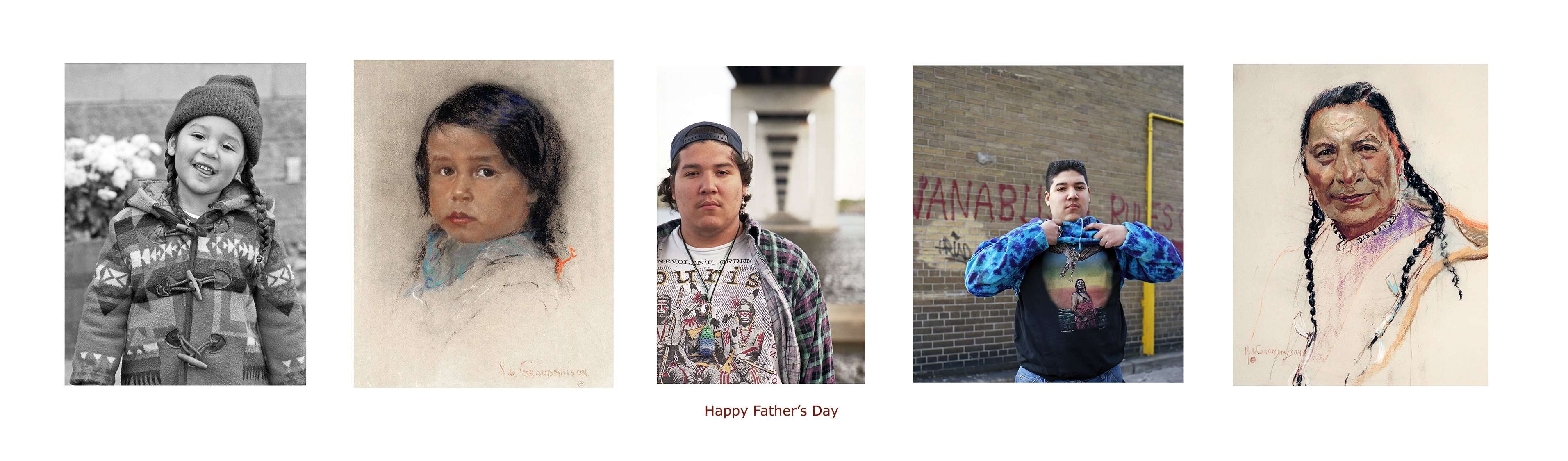
11. Happy Father’s Day (2015/2016) pigment print on archival paper
KEY TO IMAGES (left to right):
Jeff Thomas, Bear Portrait, Braids and Pendleton Coat (1979) Buffalo, New York, Cottage and Maryland. GPS: 42.8977, -78.88088
Nicholas de Grandmaison, Unidentified Blackfoot Boy (n.d.) Lethbridge, Alberta Courtesy of the University of Lethbridge Art Gallery/4307. GPS: 49.67761 -112.86014
Jeff Thomas, Bear Portrait, Slow Bull Revealed (1992) Queen Street West alley, Toronto, Ontario. GPS: unable to locate the exact location.
Jeff Thomas, Bear Portrait, Three Pawnee Men Revealed (1993) Belleville, Ontario. GPS: 44.151033 -77.3882
Nicholas De Grandmaison, Riding at the Door, Blood Indian (Itsoksi ksisto kitopi), (1948) Lethbridge, Alberta. Courtesy of the University of Lethbridge Art Gallery /19. 2012.19. GPS: 49.67761 -112.86014
![]()
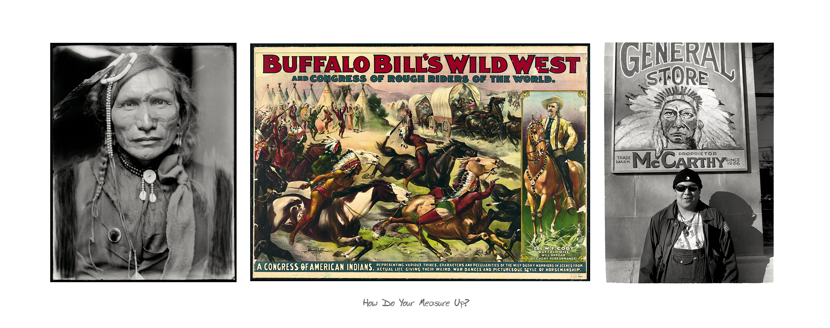
12. How Do You Measure Up? (2010/2014) pigment print on archival paper
KEY TO IMAGES (left to right):
Gertrude Kasebier (1852 – 1943), Iron White Man, a Sioux Indian from Buffalo Bill’s Wild West Show (ca. 1900) Courtesy of the Library of Congress/LC-K2-62
Buffalo Bill’s Wild West And Congress Of Rough Riders Of The World: A Congress Of American Indians, color lithograph (1899) Courtesy of the Library of Congress/LC-USZ62-1164
Jeff Thomas, Bear Thomas (1994) Toronto, Ontario. GPS: 43.6439,-79.395183
![]()
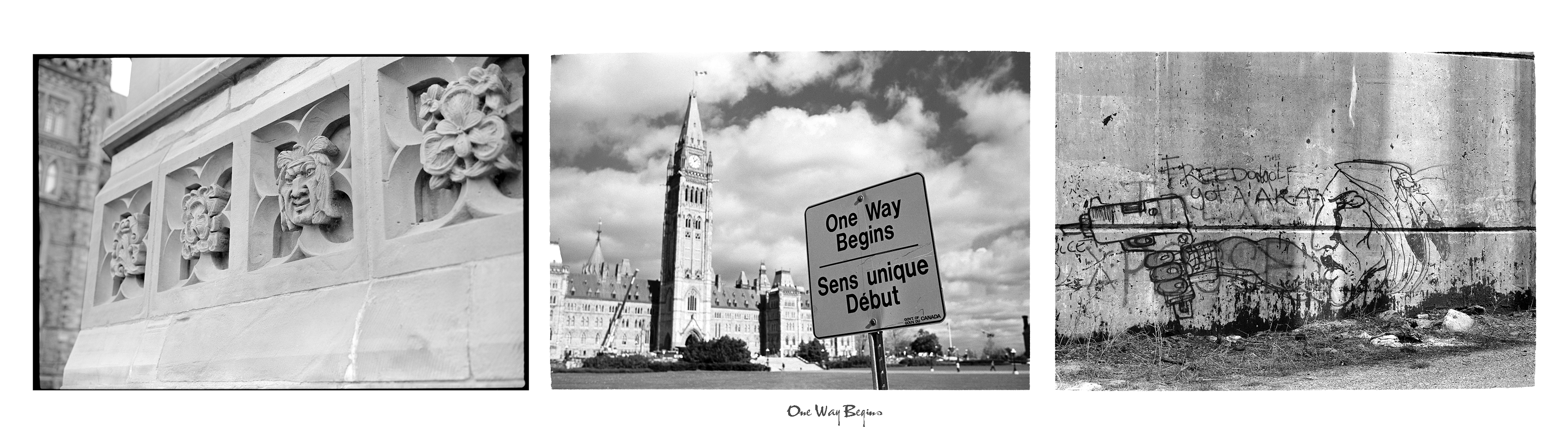
13. One Way Begins (2011) pigment print on archival paper
When I photographed the “One Way Begins” sign on Parliament Hill in Ottawa, Ontario, with its ornate architecture in the background, along with the surrounding edifices of government power and control, I saw in my mind, the lone Indian figure (Anishinabe Scout) in Major’s Hill Park, kneeling in defiance of his forced relocation from the Champlain monument to Major’s Hill Park.
KEY TO IMAGES (left to right):
Jeff Thomas, Parliament Hill, Centre Block with a carved Indian face (1998) Parliament Hill, Ottawa, Ontario. GPS: 45.4246,-75.699617
Jeff Thomas, One Way Begins (1998) Parliament Hill, Ottawa, Ontario. GPS: 45.4246,-75.699617
Jeff Thomas, unknown Mohawk graffiti artist, Mercier Bridge pier (1995) Kahnawake Mohawk Territory, Quebec. GPS: 45.40863, -73.65925
![]()
View the other Portfolios from this series:
STRONG HEARTS: MY JOURNEY WITH BIRDMAN
REBINDING THE NORTH AMERICAN INDIAN
THE EUROPEANIZATION OF TURTLE ISLAND
![]()


![]()