Rebinding The North American Indian

![]()
Click on anchor points to view corresponding panel and title. You can move the map around by clicking and dragging. View a larger version of the map by clicking on the [ ] brackets on the top right of the map.
![]()
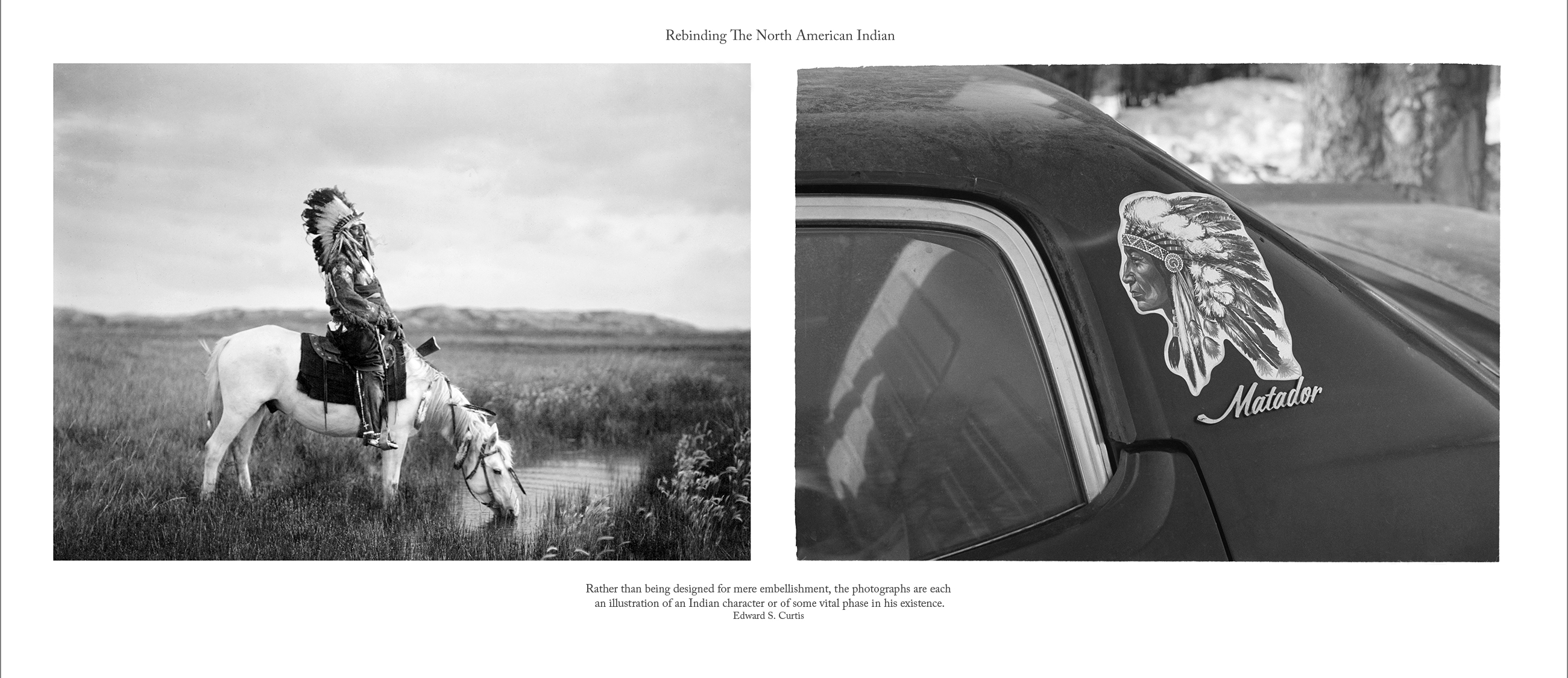
1. Indian Car (2013) pigment print on archival paper
KEY TO IMAGES (left to right)
Edward S. Curtis, An Oasis in the Badlands (c.1905) Cetan-luta (Red Hawk) Lakota-Oglala, Lakota (Oglala), longitude & latitude not available, Courtesy of the Library of Congress/LC-USZ62-107914
NOTE: This picture was made in the heart of the Badlands of South Dakota. The subject is the sub-chief Red Hawk, a sketch of whose life account is given on page 188 of Volume III.
PLATE CAPTION: RED HAWK, Cheta”-luta (” Scarlet Hawk”) Ogalala. Born I854. First war-party in 1865 under Crazy Horse, against troops. Led an unsuccessful war-party at twenty-two against Shoshoni. First coup when twelve horse-raiding Blackfeet were discovered in a creek bottom and annihilated. Led another party against Shoshoni, but failed to find them; encountered and surrounded a white-horse troop. From a hill overlooking the fight Red Hawk saw soldiers dismount and charge. The Lakota fled, leaving him alone. A soldier came close and fired, but missed. Red Hawk did likewise, but while the soldier was reloading his carbine he fired again with his Winchester and heard a thump and “O-h-h-h! ” A Cheyenne boy on horseback rushed in and struck the soldier, counting coup. Engaged in twenty battles, many with troops, among them the Custer fight of 1876; others with Pawnee, Apsaroke, Shoshoni, Cheyenne, and even with Sioux scouts. Red Hawk fasted twice. The second time, after two days and a night, he saw a vision. As he slept, something from the west came galloping and panting. It circled about him, then went away. A voice said, “Look! I told you there would be many horses!” He looked, and saw a man holding green grass in his hand. Again the voice said, “There will be many horses about this season”; then he saw the speaker was a rose-hip, half red, half green. Then the creature went away and became a yellow-headed blackbird. It alighted on one of the offering poles, which bent as if under a great weight. The bird became a man again, and said, “Look at this! ” Red Hawk saw a village, into which the man threw two long-haired human heads. Said the voice, “I came to tell you something, and I have now told you. You have done right.” Then the creature, becoming a bird, rose and disappeared in the south. Red Hawk slept, and heard a voice saying, “Look at your village!” He saw four women going around the village with their hair on the top of their heads, and their legs aflame. Following them was a naked man, mourning and singing the death-song. Again he slept, and felt a hand on his head, shaking him, and as he awoke a voice said, “Arise, behold the face of your grandfather!” He looked to the eastward and saw the sun peeping above a ridge. The voice continued: “Listen! He is coming, anxious to eat.” So he took his pipe and held the stem toward the rising sun. This time he knew he was not asleep, or dreaming: he knew he was on a hill three miles from the village. A few days later came news that of five who had gone against the enemy, four had been killed; one returned alive, and followed the four mourning wives around the camp singing the death-song. Still later they killed a Cheyenne and an Apsaroke scout, and the two heads were brought into camp. Portrait facing this page. RING THUNDER, Jaki ya”-cha”gilethka Brule. Born I840. At eighteen he accompanied a party, under Knife, against the Pawnee. He himself led twenty-three war-parties, all against the same tribe. He counted coup once, was never wounded, nor did an enemy ever strike him. At thirty-three he was elected a chief. SHIELD, Iahacha”ka Ogalala. Born I833. Accompanied a party on an expedition against the Ute when thirteen years of age. At thirty-one he led a party of horse-raiders into the Apsaroke country. He was engaged altogether in eight severe fights, mostly against the Apsaroke. He counted five coups, one of them a first honor.
Jeff Thomas, Indian Car (1982) Buffalo, New York, Cottage Street. GPS: 42.89756, -78.8806
![]()

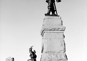
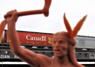
2. Acts of Commemoration (2009/2015) pigment print on archival paper
I am firmly persuaded that the true interests of the aborigines and of the State alike require that every effort should be made to aid the red man in lifting himself out of his condition of tutelage and dependence, and that it is clearly our wisdom and our duty, through education and every other means, to prepare him for a higher civilization by encouraging him to assume the privileges and responsibilities of full citizenship.
~D. Laird, Minister of the Interior. Department Of The Interior, January 31, 1876
KEY TO IMAGES (left to right):
Jeff Thomas, Samuel de Champlain Monument (2002) Orillia, Ontario. GPS: 44.61669, -79.41345
Edward S. Curtis, “The Oath,” Apsaroke (Crow) Men (November 9, 1908) Crow Reservation, Montana. Courtesy of the Library of Congress/LC-USZ62-46992. Note: Frontispiece for Volume 4 of TNAI. Approximate longitude & latitude GPS: 45.60414, -107.46452,
Jeff Thomas, Samuel de Champlain monument (1996) Sculptor Hamilton McCarthy, Ottawa, Ontario, Canada. GPS: 45.4294, -75.7016
The monument was unveiled in 1915, commemorating the 300th anniversary of Champlain’s second trip.
![]()
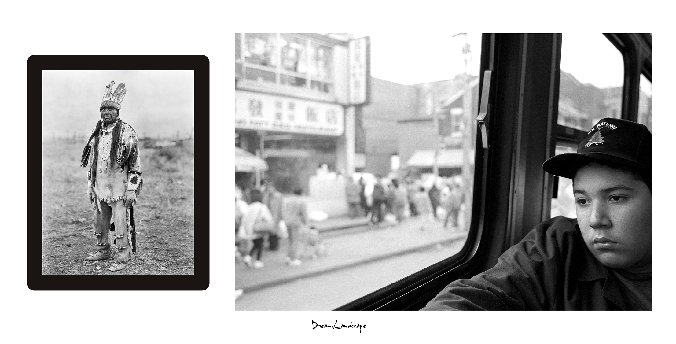
3. Dream/Landscape (2018) pigment print on archival paper
TRAVELOGUE:
I photographed Bear on the Dundas Street car during a visit in Toronto. The portrait has a sense of my childhood, reminding me of watching the world pass by in my father’s car. I dreamed of one day pulling over to investigate an interesting site. The memory led to my work on urban sites, devoid of any Indigenous content. There are so few cultural anchors to work with in the city, that one has a feeling of cultural invisibility. My imagination often came into play, wondering what the world looked like.
KEY TO IMAGES (left to right):
Edward S. Curtis, A Klamath in Costume (1923) published in Volume 15 of The North American Indian, courtesy Library of Congress/LC-USZ62-123299
Jeff Thomas, Bear (Witness) Thomas, Dundas Streetcar (1990) Toronto, Ontario. GPS: 43.65351, -79.3953
The portrait of the Klamath man was published in Volume 12 of The North American Indian, and the following text accompanies his portrait, describing the type of clothing worn by the men. There is a sense of lost in time with the diffused background, but Curtis does include the following description of the Klamath homeland:
The territory of the Klamath was bounded on the west by the Cascade mountains, which form the divide between the Klamath River basin and Rogue river and other streams flowing westward into the Pacific. Northward it extended to the vicinity of Bend, in latitude 44o, thus including, in the headwaters of Deschutes river, a portion of the Columbia River drainage. On the east it took in the drainage of Sycan marsh, and a portion of the drainage of Goose Lake, which lies partly in Oregon and partly in California. The southerly boundary was approximately identical with the Oregon California line. With the exception of small areas in Crook and Lake counties, Klamath territory almost coincided with what is now Klamath county. South of the Klamath were the Modoc, who held the country from the Oregon-California line to the divide between Klamath river and Pit river, where they adjoined Achomawi territory. Roughly, then, the Klamath held the country tributary to Klamath marsh, Upper Klamath lake, the northern part of Lower Klamath lake, and the northern part of Goose lake.
![]()
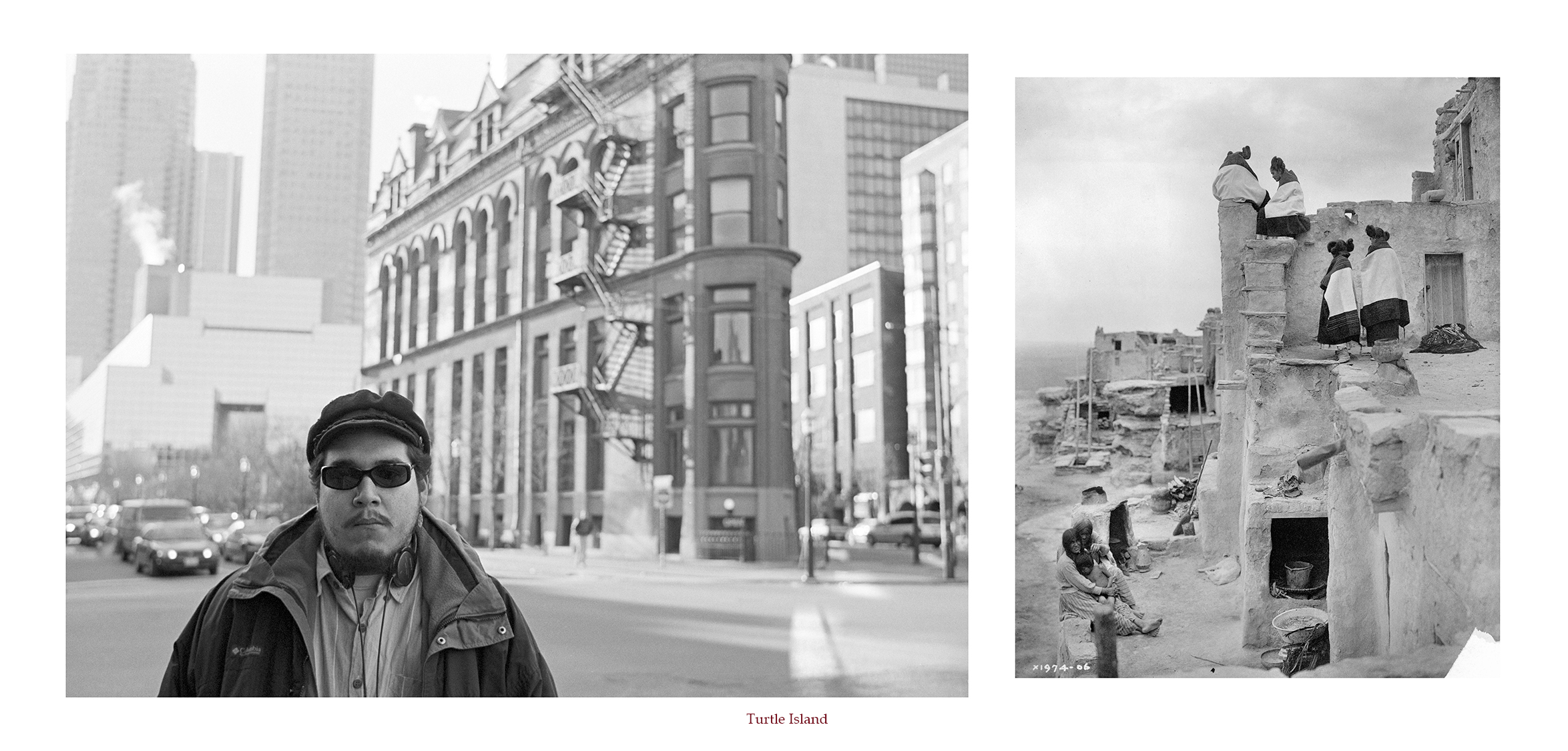
4. Turtle Island (2018) pigment print on archival paper
KEY TO IMAGES (left to right):
Jeff Thomas, Bear (Witness) Thomas (1997) Toronto, Ontario, GPS: 43.64836, -79.373
Edward S. Curtis, On the housetop, Hopi (c. 1906) Courtesy of: Library of Congress/ LC-USZ62-46952 Hopi women seated and standing on pueblo buildings. Published in: The North American Indian / Edward S. Curtis. [Seattle, Wash.] : Edward S. Curtis, 1907-30, Suppl. v 12., pl. 409.
![]()
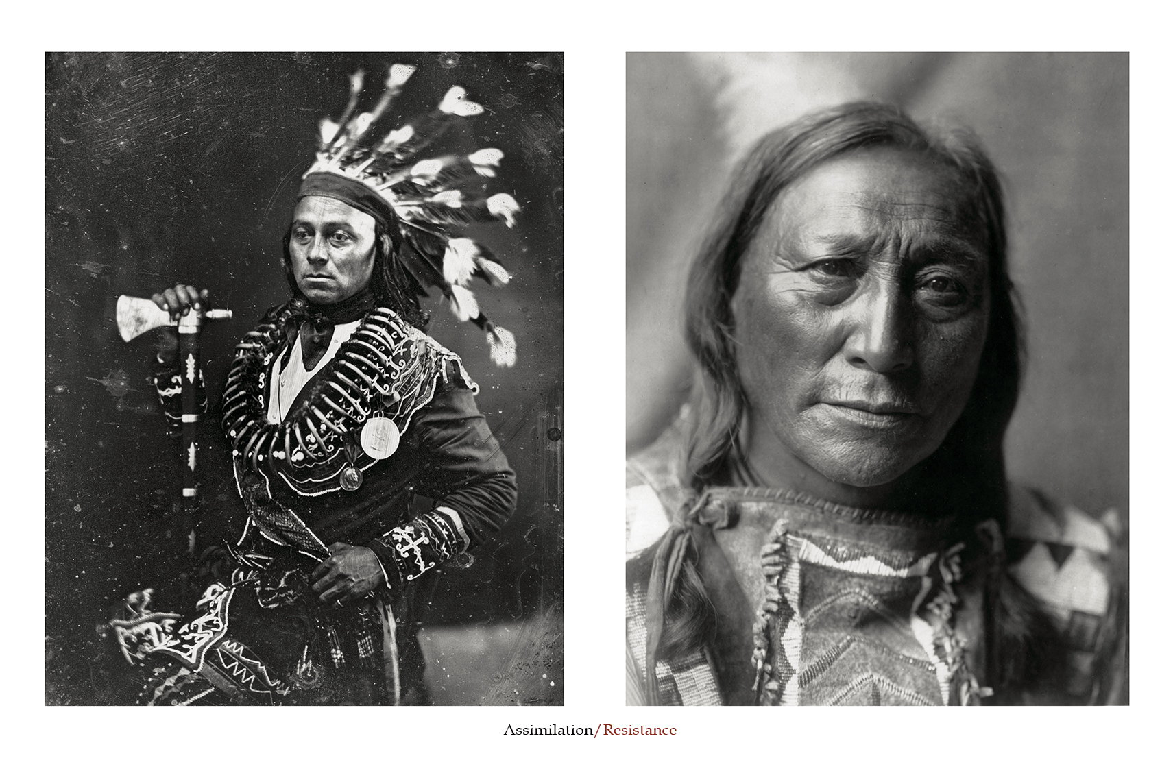
5. Assimilation/Resistance (2010) pigment print on archival paper
KEY TO IMAGES (left to right):
Photographer unknown, Maun-gua-daus (also Maungwudaus), alias George Henry (Mississauga), (1846-1848 daguerreotype) Courtesy: Maun-gua-daus Collection/Library and Archives Canada/PA-125840
Maungwudaus is credited as one of the first North American Indians to be photographed, in c. 1843. He was a chief of the Mississauga Indians and worked for the Department of Indian Affairs as an interpreter. He also performed in George Catlin’s Indian Gallery when it toured in Europe. The Mississauga were forced out of their settlement near present-day Toronto, Ontario by white settlers and eventually settled on a section of land at the Six Nations Reserve. The New Credit Reserve is just down the road from my elders home and I recall the Mississauga coming up in their conversations.
Edward S. Curtis, Hollow Horn Bear, Brulé (Sioux), (c.1850-1913) December 26, 1907, Courtesy of the Library Congress/LC-USZ62-5367
Curtis included the following biography in Volume 3 of The North American Indian:
Hollow Horn Bear was born in I850. His first war-party was at twelve, against the Pawnee. At nineteen he took the pipe and led a party, which killed a number of Pawnee wood-haulers. He struck a first coup “kill right” – in that battle. After that his father, Iron Shell, desired him to take that name, but he said he would take his grandfather’s name instead, and makes the name Hollow Horn Bear good. During his career as a warrior he counted coup many times and participated in twenty-three fights with Pawnee, Omaha, Ponca, Shoshoni, Ute, Arikara, and United States troops. He was present at the Custer fight.
![]()
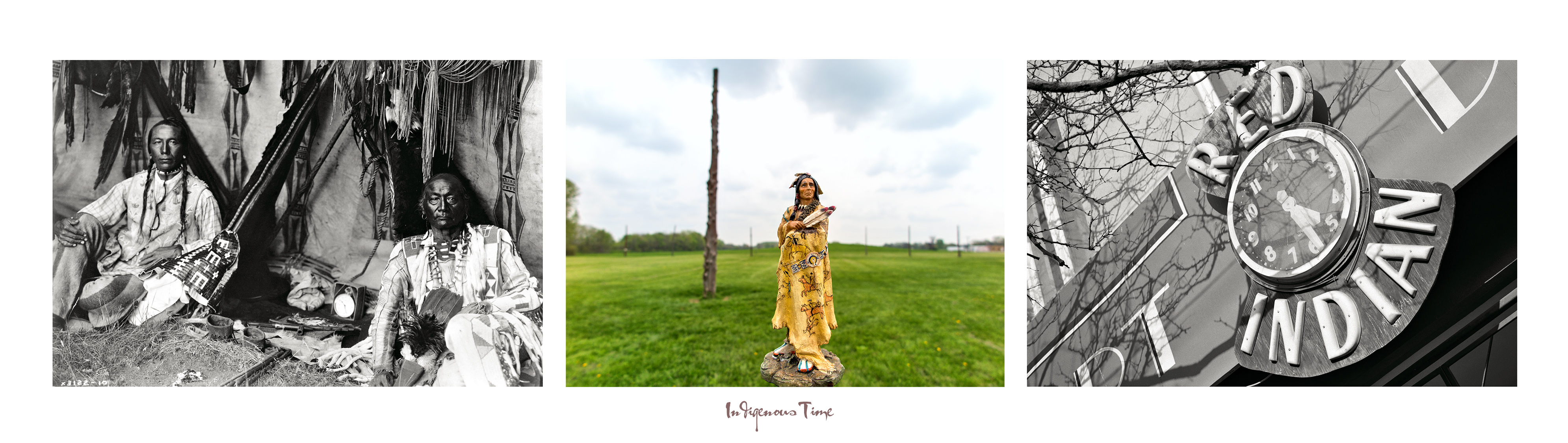
6. Indian Time, Mississippian Astronomy Site (2009/2016) pigment print on archival paper
TRAVELOGUE: Woodhenge, Collinsville, Illinois. April 18, 2015, Cahokia complex
I am just a short distance from Monks Mound now and posing Buffalo Robe in front of the Woodhenge circle. What came to mind while I studied the site was a previous diptych panel I made titled “Indian Time.” The first image was made by Edward S. Curtis and shows a Blackfoot father and son seated in their tipi with a clock placed between them. The second image shows an outdoor sign for an antique store in Toronto, Ontario, with a clock surrounded by the words Red Indian. But I also felt something was missing and I needed a third image.
The negative perception and stereotype that Indians were primitive and had no sense of time keeping was on my mind for a third image. In Curtis’s 20 volume publication “The North American Indian,” the clock has been removed and pipes are highlighted and noted in the author’s caption. Luckily I found a version of the Piegan Lodge with the clock on the Library of Congress website. Now I had an image to add to the panel and complete the triptych.
KEY TO IMAGES (left to right):
Edward S. Curtis, In a Piegan Lodge, Little Plume and son Yellow Kidney (March 11, 1910) Institution: courtesy of the Library of Congress/LC-USZ62-051432, Washington, D.C. GPS: 48.66664, -112.91758,
Plate 188, “In a Piegan Lodge,” 1910; caption:
Little Plume with his son Yellow Kidney occupies the position of honor, the space at the rear opposite the entrance. The picture is full of suggestion of the various Indian activities. In a prominent place lie the ever present pipe and its accessories on the tobacco cutting board. From the lodge poles hang the buffalo skin shield, the long medicine bundle, an eagle wing fan and a deerskin articles for accoutering the horse. The upper end of the rope is attached to the intersection of the lodge poles and in stormy weather the lower end is made fast to a stake near the centre of the floor space.
Jeff Thomas, “Woodhenge” Ancient Mississippian Solar Calendar site (2015) Collinsville, Illinois. GPS: 38.6599,-90.075133
Jeff Thomas, Red Indian Art Deco Incorporated (2003) Queen Street West, Toronto, Ontario. GPS: 43.648,-79.40005
![]()
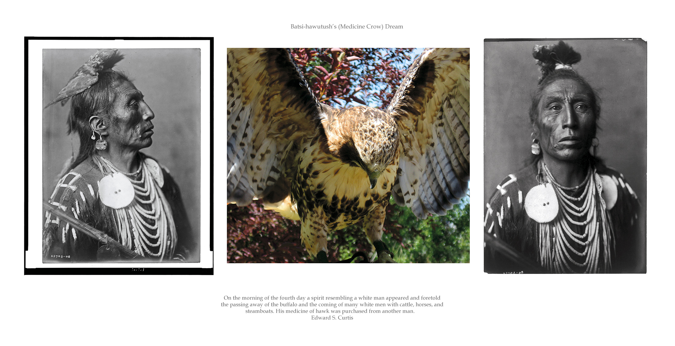
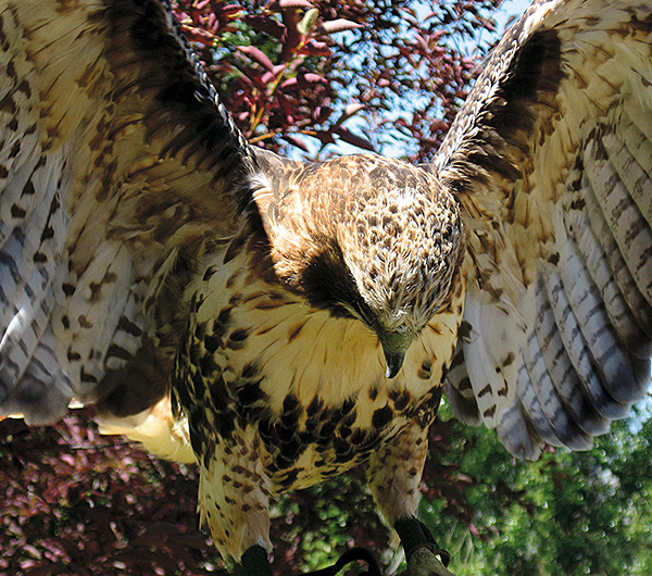
7. The Crossing Place (2005/2017) pigment print on archival paper
TRAVELOGUE: Coaldale, Alberta, June 6, 2006, Alberta Birds of Prey Foundation
While in Lethbridge, Alberta, we made a side trip to nearby Coaldale to take part in the flying demonstration with the birds of prey. The image shows a Red-Tailed Hawk landing on my arm. Now I have an image for my new work with Medicine Crow, who was photographed by Edward S. Curtis. My objective is to present the revered relationship men like Medline Crow had with the bird of prey.
Edward Curtis: The passing of every old man or woman means the passing of some tradition, some knowledge of sacred rites possessed by no other; consequently the information that is to be gathered, for the benefit of future generations, respecting the mode of life of one of the great races of mankind, must be collected at once or the opportunity will be lost for all time. It is this need that has inspired the present task.
KEY TO IMAGES (left to right):
Edward S. Curtis, Medicine Crow, Apsaroke, (Crow), (c. 1908) Crow Reservation, Montana, Institution: courtesy of the Library of Congress/LC- USZ62-106886. Approximate longitude & latitude GPS: 45.36090, -107.27643,
Brenda Lafleur, Red Tail Hawk (2006) Alberta Birds of Prey Foundation, Coaldale, Alberta. GPS: 49.73164, -112.62746 (the hawk is landing on my arm)
Edward S. Curtis, Medicine Crow (frontal), Apsaroke (Crow), (c. 1908) Crow reservation, Montana. courtesy of the Library of Congress/LC-USZ62-98537, this image was not published in The North American Indian. GPS: 45.38329, -107.83399,
![]()

8. Return the Gaze (2009/2016) pigment print on archival paper
KEY TO IMAGES (left to right):
Edward S. Curtis, Swallow Bird – Apsorake (Crow) tribe (c. 1908) photographed by Edward S. Curtis, Crow Reservation, Montana, Courtesy of the Library of Congress/LC-USZ62-106767. GPS: 45.60414, -107.46452,
Left and Right: Jeff Thomas, Joseph Crowe, Saulteaux tribe (1990) Sioux Valley Powwow Grounds, Manitoba. GPS: 49.85565, -100.4886
![]()
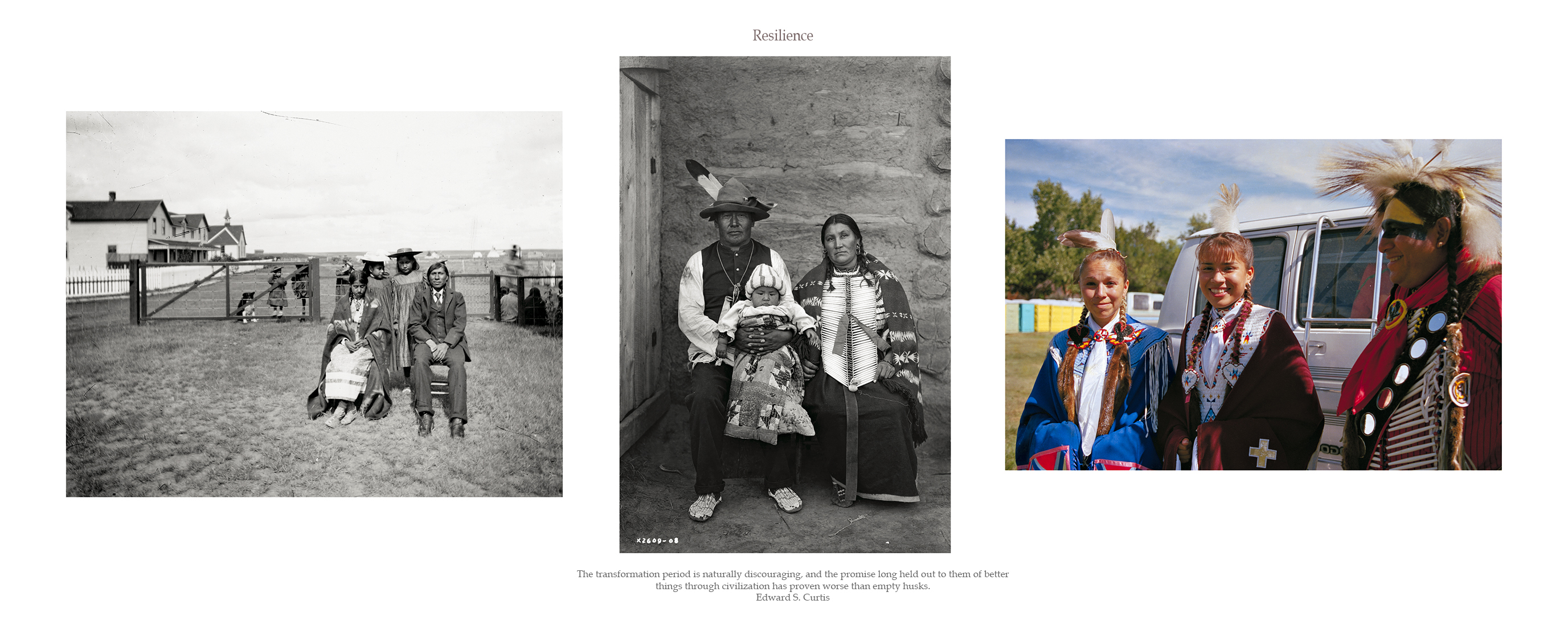
9. Resilience: Indian Families (2016) pigment print on archival paper
KEY TO IMAGES (left to right):
Unknown, Jim Abikoki and family (c. 1900) in front of the fence surrounding the Anglican Mission on the Blackfoot (Siksika) Reserve, Southern Alberta. Courtesy of the Glenbow Museum/No: NC-5-8. Approximate longitude & latitude GPS: 50.7605, -112.9084.
Edward S. Curtis, Yellow Bone Woman Family, Arikara tribe (c. 1908) North Dakota. Courtesy of the Library of Congress LC-USZ62-101183. GPS: 47.682417,-102.321433,
Jeff Thomas, Ron Good Eagle Family (1996) Bismarck, North Dakota, United Tribes Technical College in Bismarck, North Dakota. GPS: 46.765367,-100.753583
![]()

10. Resistance is NOT Futile (2009) pigment print on archival paper
EDWARD S. CURTIS: Vanishing race – Navajo, Portfolio 1, plate no. 1: The thought which this picture is meant to convey is that the Indians as a race, already shorn of their tribal strength and stripped of their primitive dress, are passing into the darkness of an unknown future. Feeling that the picture expresses so much of the thought that inspired the entire work, the author has chosen it as the first of the series.
KEY TO IMAGES (left to right):
Edward S. Curtis, Ndee Sangochonh, Apache (c. 1906) Courtesy The Library of Congress/LC-USZ62-106797. Approximate longitude & latitude GPS: 33.91671, -110.16732,
Jeff Thomas, “The End Is Near,” Lebreton Flats (2007) Ottawa, Ontario. GPS: 45.40921, -75.71148
Edward S. Curtis, Nova, (Pursuing a Butterfly, Badger clan) Hopi, Walpi-Pueblo (1906) Courtesy of the Library of Congress/LC-USZ62-124180. Approximate longitude & latitude GPS: 35.78333, -110.50346
![]()
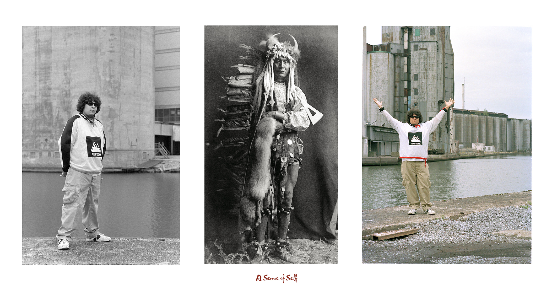
11. Self-determined (2009/2017) pigment print on archival paper
The freedom to make your own choices and tell your own story.
KEY TO IMAGES (left to right):
Jeff Thomas, Bear Thomas (1997) Buffalo Creek, Buffalo, New York. GPS: 42.86436, -78.86183
Edward S. Curtis, Iron Breast, Piegan (c. 1900.) Courtesy of Library and Archives Canada/C-019972. Approximate longitude & latitude GPS: 48.66664, -112.91758
Jeff Thomas, Bear Thomas (1997) Buffalo Creek, Buffalo, New York. GPS: 42.86436, -78.86183
![]()
View the other Portfolios from this series:
STRONG HEARTS: MY JOURNEY WITH BIRDMAN
REBINDING THE NORTH AMERICAN INDIAN
THE EUROPEANIZATION OF TURTLE ISLAND
![]()


![]()
[…] REBINDING THE NORTH AMERICAN INDIAN […]
[…] REBINDING THE NORTH AMERICAN INDIAN […]